
Some time ago in my ongoing reading of the 1964 Funk & Wagnalls Standard Reference Encyclopedia, in the entry on Arizona, I found this conundrum. The entry states that Arizona is "bounded on the N. by Utah, on the E. by New Mexico, on the S. by Mexico, and on the W. by California and Nevada." But what about Colorado? I asked myself, looking at the map. There it is at the N.E. corner. The boundary lines cross do they not?
This is probably a mathematical question. If the boundary lines have no thickness and the point where they intersect is 0 in dimension, I guess you could argue there is no point at which the two states touch. But such a point does not exist in reality. It must be possible for people to cross from one state to the other at this point. Were Funk & Wagnalls just wrong to exclude Colorado as one of the states that bounds Arizona? Or is this a principle in geography--states or any locations that are kitty corner to each other are not considered to share a boundary? What do people in Arizona and Colorado think about this?
Results 1 to 12 of 12
Thread: Is Arizona bounded by Colorado?
-
06-27-2023, 11:14 PM #1Retired

- Join Date
- Apr 2014
- Posts
- 18,747
 Is Arizona bounded by Colorado?
-
06-28-2023, 01:03 PM #2Loony
- Join Date
- Apr 2014
- Location
- Running Springs, California
- Posts
- 9,382
There is a place called four corners where you can stand in all four states:
https://en.wikipedia.org/wiki/Four_Corners
So I would say that Arizona bounds all three states at that particular location. Mathematically, the corner is basically dimensionless, though.Every day is a gift, not a given right.
-
06-28-2023, 01:16 PM #3Uncanny Member
- Join Date
- May 2014
- Posts
- 29,974
"Bounded" probably isn't used for places where a teeny-weeny area comes in contact with another teeny-weeny area. It may require a bit more shared territorial area. Originally Posted by Jim Kelly

-
06-28-2023, 04:23 PM #4insulin4all
- Join Date
- Dec 2014
- Posts
- 10,943
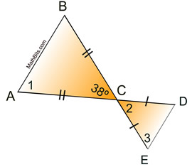
Basically, the question boils down to are triangles ABC and CDE touching each other? Mathematically, as had been mentioned, they are touching and one can draw a straight line from Arizona into Colorado without it going to any other state. Legally though, I'd go by laws requiring permission of adjoining properties to do some sort of work. Would properties with a single point of contact count?
 Ill don the mask and wear the cape
If I am super, how can I wait?
-
06-28-2023, 04:41 PM #5Retired
- Join Date
- Apr 2014
- Posts
- 18,747
I guess it might be a language thing and Funk & Wagnalls just has a special usage for "bounded." But mathematically, it seems to me that there is a point of contact between the two states, without any other states being involved. So if they had a police check point, they could interdict passage between Arizona and Colorado at that point, without involving Utah or New Mexico. Or I could be all wrong.
-
06-28-2023, 06:08 PM #6Loony
- Join Date
- Apr 2014
- Location
- Running Springs, California
- Posts
- 9,382
Well if you look at the rules of D&D, an adjacent square includes the one diagonally from where you are at. In other words you can hit a monster in that square, there for it is considered to be adjacent.
Can you throw a rock into all three other states from Arizona? Yes you can. Adjacent.Every day is a gift, not a given right.
-
06-28-2023, 06:57 PM #7Uncanny Member
- Join Date
- May 2014
- Posts
- 29,974
Originally Posted by Jim Kelly
But the term in the original post was "bounded", not "adjacent". Originally Posted by Scott Taylor
-
06-30-2023, 07:36 PM #8Extraordinary Member
- Join Date
- Nov 2019
- Posts
- 6,168
Place is probably infested with vampires, witches, werewolves. aliens, and killer robots. Originally Posted by Scott Taylor
-
07-01-2023, 12:20 AM #9Retired
- Join Date
- Apr 2014
- Posts
- 18,747
To put it another way, in chess, is a white square only bounded by black squares or by both black squares and white squares? And the reverse for a black square. I always ask myself, when the knight moves, is it physically moving across the squares to get to its destination or is it teleporting like Nightcrawler to its destination square?
-
07-01-2023, 07:13 AM #10insulin4all
- Join Date
- Dec 2014
- Posts
- 10,943
The knight is usually considered to have a teleporting nature as the squares are pretty much irrelevant to the knight's move. The piece most fitting here is the king, which is able to move one square vertically, horizontally or diagonally. The movement has also been described to to any adjoining square. Originally Posted by Jim Kelly
Ill don the mask and wear the cape
If I am super, how can I wait?
-
07-01-2023, 08:21 AM #11Astonishing Member
- Join Date
- Jun 2014
- Posts
- 3,473
Dang, someone already beat me to it.
-
07-03-2023, 02:46 PM #12Loony
- Join Date
- Apr 2014
- Location
- Running Springs, California
- Posts
- 9,382
If the diagonal squares to the white square were black instead of white, would it make a difference in the game? I think so, therefore the diagonal squares are part of the boundary. Originally Posted by Jim Kelly
Every day is a gift, not a given right.

 Reply With Quote


